Water and soils

© Mike Dodd

Water and soils

Water and soils are key elements in shaping the character of floodplain-meadow plant communities.

Water

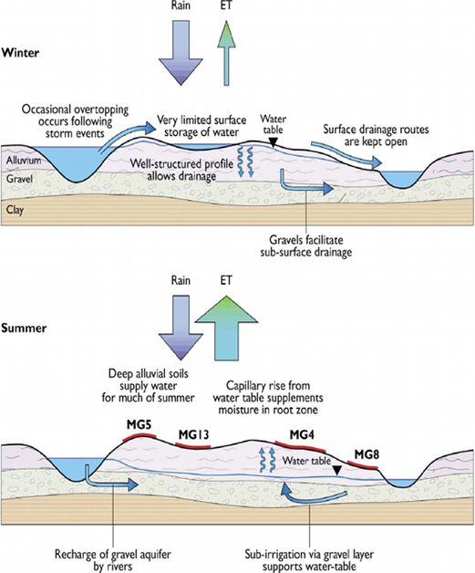
Great burnet-meadow foxtail (MG4) meadows require adequate surface drainage to allow water to flow freely back to watercourses following a flood, and to prevent the retention of rainwater on the surface for long periods. Many meadows lie over river gravel deposits which ensures a well drained site.

They are generally intolerant of water logging during the growing season, to the extent that too much water can be more damaging than too little at this time of year.

These grasslands have developed under a system of traditional agricultural management and are therefore reliant on the surface drainage system developed and maintained by farmers. Surface drainage provided by features such as grips, gutters and foot drains should be regularly maintained to ensure their continued function. The input of nutrients locked up on the sediment deposited after a flood is important to compensate for nutrient losses to the system during the hay cut.

Past flood protection works that involved deepening, straightening or embanking rivers can be detrimental to these meadows. Apart from the direct loss of habitat, these changes may result in a reduction of winter floods on the site, or in a prolonged period of waterlogging during summer flooding, when floodwater is trapped on the floodplain by the embankments. The various hydrological mechanisms that can support the Burnet floodplain meadow plant community are shown below:

The diagram shows the movement of water from rain into groundwater and up again through evapotranspiration. Gravels under the meadow support sub-surface irrigation which helps to determine which plant communities occur on the floodplain surface and where they are found.

Soils

Coarse sediments were widely deposited on floodplains following the end of the last Ice Age around 11,500 years ago. Melting snow fields and ice sheets created swollen rivers each spring that eroded upland areas and re-deposited the transported material onto lowland floodplains. The resultant layers of sand and gravel still underlie many floodplains and are often referred to as ‘terrace’ deposits. These terrace deposits play a pivotal role in the hydrology of floodplains, allowing water to flow freely through them.

Estimates suggest that some floodplains have a greater volume of water travelling through sub-surface gravels than in the river channel itself. As the winters warmed, the periods of meltwater spate declined in frequency and strength, and the speed of water crossing floodplains became slower. Slow-moving water drops its fine sediment and this forms the basis of alluvial soils. The depth of alluvial soil that has accumulated above terrace deposits on meadow sites can vary from just 15 cm to as much as three metres.

Soil structure and soil type are critical in determining plant species diversity and in the ability of soil to deliver other benefits such as carbon storage, water storage and food production.

Some soil characteristics, such as the soil profile, texture and structure, can be explored through observation in the field. More detailed information about physical structure requires laboratory analysis of soil samples or more complex field measurements.