Last year we were asked by Worcestershire County Council (WCC), to try and make an assessment of the potential for soil carbon storage if more of the county's floodplains were managed as meadows, with a long-term objective for them to be species-rich. We have already collected soil carbon data from a number of ancient floodplain meadows around England, alongside soil carbon data from other floodplain land uses, including arable, and non species-rich permanent grasslands. Our data has come from the Thames catchment, the Severn and Avon catchments in Gloucestershire and Worcestershire, and the Ouse catchment in Cambridgeshire. Our data is showing that species-rich meadows can contain as much as 200 t/ha carbon within the top 50 cm of soil. We felt we had a reasonable dataset so we agreed to have a go.
We were asked to: produce a literature review on soil carbon in floodplain grasslands; try and estimate the existing soil carbon in the county, based on current extent of species-rich floodplain meadow; attempt to cost how much it would be to restore floodplain meadows; and then estimate how much soil carbon would be accumulated as a result. WCC wanted to use our findings to help in developing their Local Nature Recovery Strategy (LNRS) and to explore whether a carbon trading mechanism was feasible in the county.
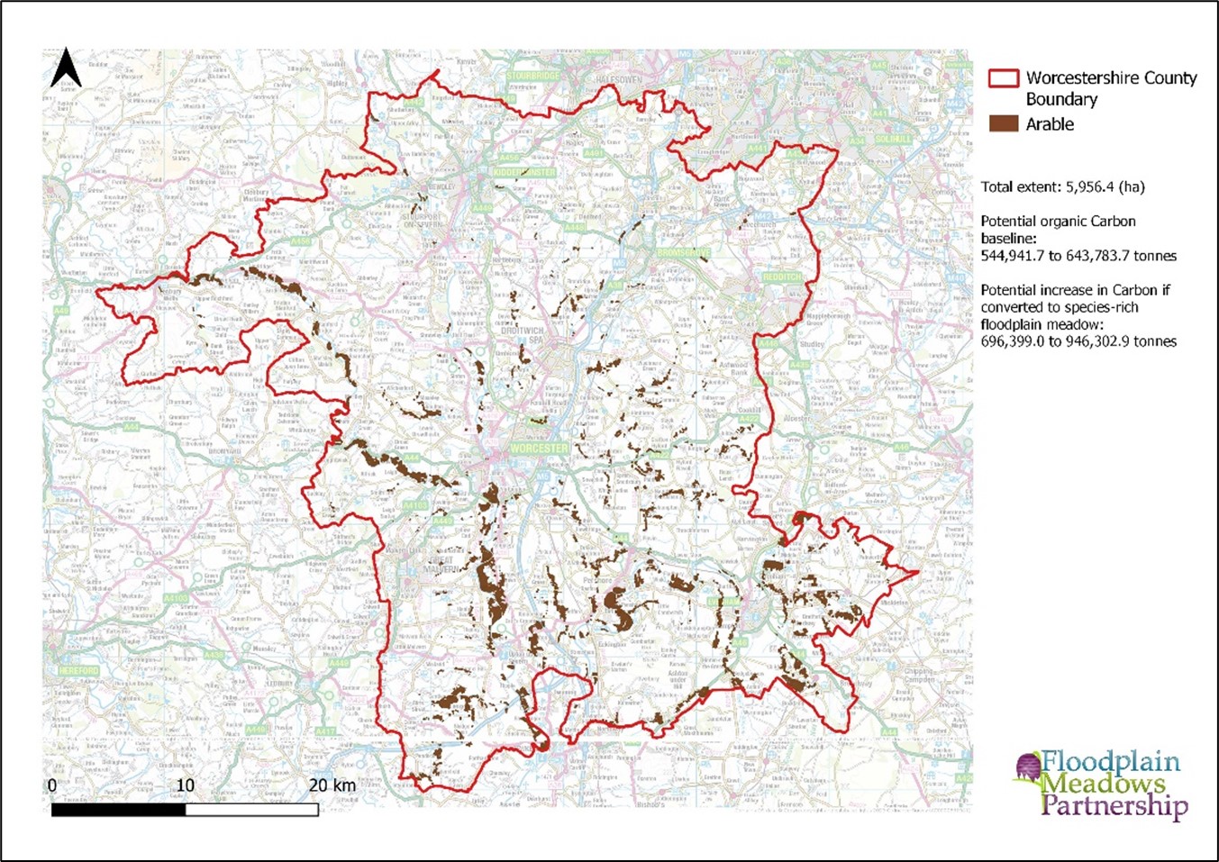
Three key maps were produced – showing the extent of existing floodplain meadows, extent of arable land in the floodplain and extent of permanent grassland, excluding species-rich floodplain meadow. Two of these maps are shown below.
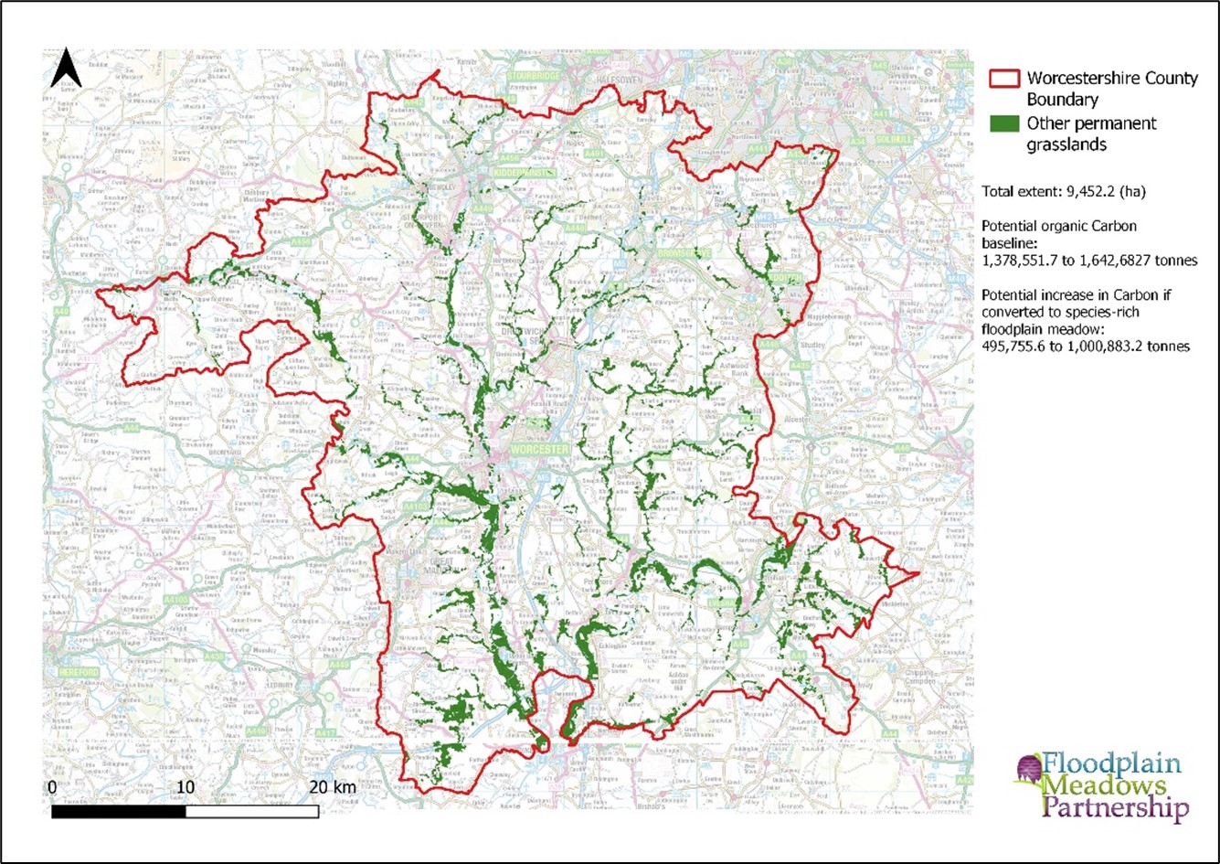 The distribution of other permanent grasslands in floodplains in Worcestershire, showing extent in ha, current extent of organic carbon, and potential if it were all restored to species rich floodplain meadow.
Our estimates for soil carbon suggest that if all the arable and permanent non species-rich grassland were converted to floodplain meadow, we would see an increase of between 1 and 2 million tonnes of carbon stored in the long-term, with an estimated cost for restoration of £18-23 million. The full report can be read here: Worcestershire Local Nature Recovery Strategy | Worcestershire County Council
There are of course a number of caviats with this work, but conceptually it is an interesting approach which could be easily replicated elsewhere. In the meantime we are working on a paper to share our soil carbon findings, and are also looking to extend our soil carbon dataset across different soil types and water regimes.
Wider Local Nature recovery Strategy approaches
Aligned to this, LNRS delivery is now a priority across local authorities in England and many counties are starting, or are already underway with the development of these. We have been invited to take part in a number of these strategies and are therefore keen to share our experience across as many as possible and see how the different counties are approaching them. Some of our Ambassadors and other contacts are already engaged locally to help fly the flag for floodplain meadows.
Collecting baseline data that can be used to develop strategies around floodplain meadows and wider floodplain habitat restoration might be a consideration for LNRS. We have done something similar to this in two recent projects: Severn Vale (Flourishing Floodplains A Green Challenge Recovery Fund project) and in the Windrush catchment where we are just completing a strategy for floodplain meadow restoration based on a rapid floodplain grassland survey carried out in 2023 (Funded by the Farming in Protected Landscapes Scheme).
Production of a 20 year strategy for the restoration of floodplain meadows in the Windrush valley
The Windrush strategy involves working with North-East Farmer Cluster and FWAG-SW to carry out a data collection exercise over 12 months, including both desk based and field data. We collected botanical information, soil carbon data, sediment deposition and undertook an historic land use assessment. We also collated the other data already available for the catchment e.g. bird data etc.
This data is being collated into a strategy to inform longer-term restoration, primarily based on what is physically possible depending on the starting point of a particular field, with floodplain meadows as the target habitat. Where physical conditions are not suitable for restoration of floodplain meadows, restoration of other habitats should be considered.
This approach could be more widely applied even where floodplain meadows are not the primary target, using a ‘what is physically possible’ approach based on data. It is possible to a define the physical requirements for a target habitat in advance and strategically. For example there is no point targeting ponds as a restoration priority if land is very free draining and won’t hold water, or floodplain meadows if land is heavily compacted and permanently wet.
We have developed a crib sheet for floodplain meadows to be used in LNRS development. There is plenty more information behind this summary that we can provide, so please do get in touch if you are working on an LNRS and think floodplain meadows will form a part of the restoration targets for your area.